
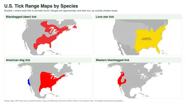

A U.S. tick map shows one clear pattern: most of the ticks that bite people live in the eastern half of the country. The blacklegged (deer) tick, lone star tick, and American dog tick all overlap across the East. Out West, the Rocky Mountain wood tick and the western blacklegged tick take over. Virginia, Maryland, and DC sit right where the three big eastern species overlap.
I’m George Schulz, third generation at Better Termite & Pest Control, and ticks come up with our customers all season long. Below is a tick map for each major species, plus the Lyme disease map, and an honest look at what these maps can and can’t tell you about your own yard.
U.S. Tick Map by Species
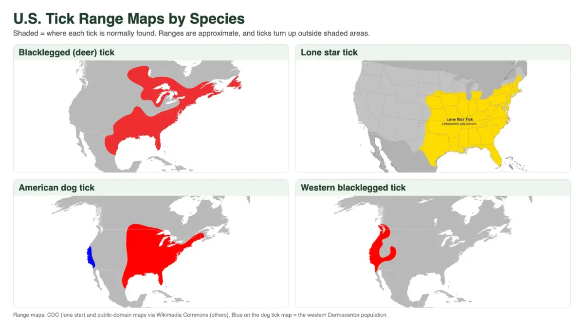
Here’s the quick version. Each panel shows the approximate range for one tick that commonly bites people.
The CDC’s Where Ticks Live page is the best official tick map. It has a separate map for each species, and it was last updated in July 2025. This table pulls together what it says about each one.
| Tick | Where the CDC says it lives | In VA, MD, and DC? |
|---|---|---|
| Blacklegged (deer) tick | Widely distributed across the eastern U.S. | Yes |
| Lone star tick | Widely distributed in the Northeast, South, and Midwest | Yes |
| American dog tick | Widely distributed east of the Rocky Mountains | Yes |
| Gulf Coast tick | Mainly the Southeast, with scattered pockets elsewhere | Mostly coastal Virginia |
| Brown dog tick | Worldwide | Yes |
| Rocky Mountain wood tick | Rocky Mountain states, from 4,000 to 10,500 feet | No |
| Western blacklegged tick | Pacific coast, especially northern California | No |
Now let’s walk through each map and what it means.
Blacklegged Tick (Deer Tick) Map
The blacklegged tick is the tick behind most Lyme disease in the East. Its range covers the eastern U.S., from the Gulf Coast north into New England and west to the upper Midwest.
This is also the tick with the most detailed map. The CDC’s blacklegged tick surveillance map shows where the tick could live. It also marks every county where the tick is “established,” with data through December 2025. A county earns that label when six or more ticks of one life stage (or ticks from more than one stage) turn up there within 12 months. After that, it keeps the label.
Lone Star Tick Map
The lone star tick covers most of the eastern half of the country. Its range runs from central Texas and Florida up through the Midwest and into New England. It has also pushed north over the past few decades.
I wrote a full breakdown of this one in our lone star tick map guide, including how far north it has spread and its link to alpha-gal syndrome. If you want species details, see our lone star tick library page.
American Dog Tick Map
The American dog tick is widely distributed east of the Rocky Mountains. West of the Rockies, the CDC now recognizes a separate, newly described species, Dermacentor similis. That’s the blue strip along the West Coast in the map above.
Dog ticks like sunnier, more open spots than deer ticks do. Think trail edges, fields, and the border where lawn meets brush.
Gulf Coast Tick Map
The Gulf Coast tick lives mainly in the southeastern U.S., with smaller pockets farther north and west. In our area, it’s most common along Virginia’s coastline rather than in Northern Virginia.
Brown Dog Tick Map
The brown dog tick doesn’t get a regional map, because the CDC lists its range simply as worldwide. As the name suggests, dogs are its main host.
Western Tick Maps: Rocky Mountain Wood Tick and Western Blacklegged Tick
Two ticks own the West. The Rocky Mountain wood tick lives in the Rocky Mountain states and southwestern Canada. It sticks to elevations from 4,000 to 10,500 feet. The western blacklegged tick lives along the Pacific coast, especially in northern California. Neither one is a DMV tick, so if you find one here, it probably hitched a ride on a traveler or a pet.
Asian Longhorned Tick Map
The Asian longhorned tick isn’t on the CDC’s species page. Instead, the USDA tracks it with its own county map. The USDA says it was first found in the U.S. outside a port of entry in November 2017, in Hunterdon County, New Jersey. Since then, it has turned up across the eastern half of the country. It now ranges from New York south to Georgia and west to Missouri.
That band puts the DMV squarely inside its range. Our Asian longhorned tick page covers how to recognize it.
Lyme Disease Map: Where Cases Get Reported
A tick range map and a disease map answer different questions. The range map says where a tick lives. The disease map says where people actually got sick.
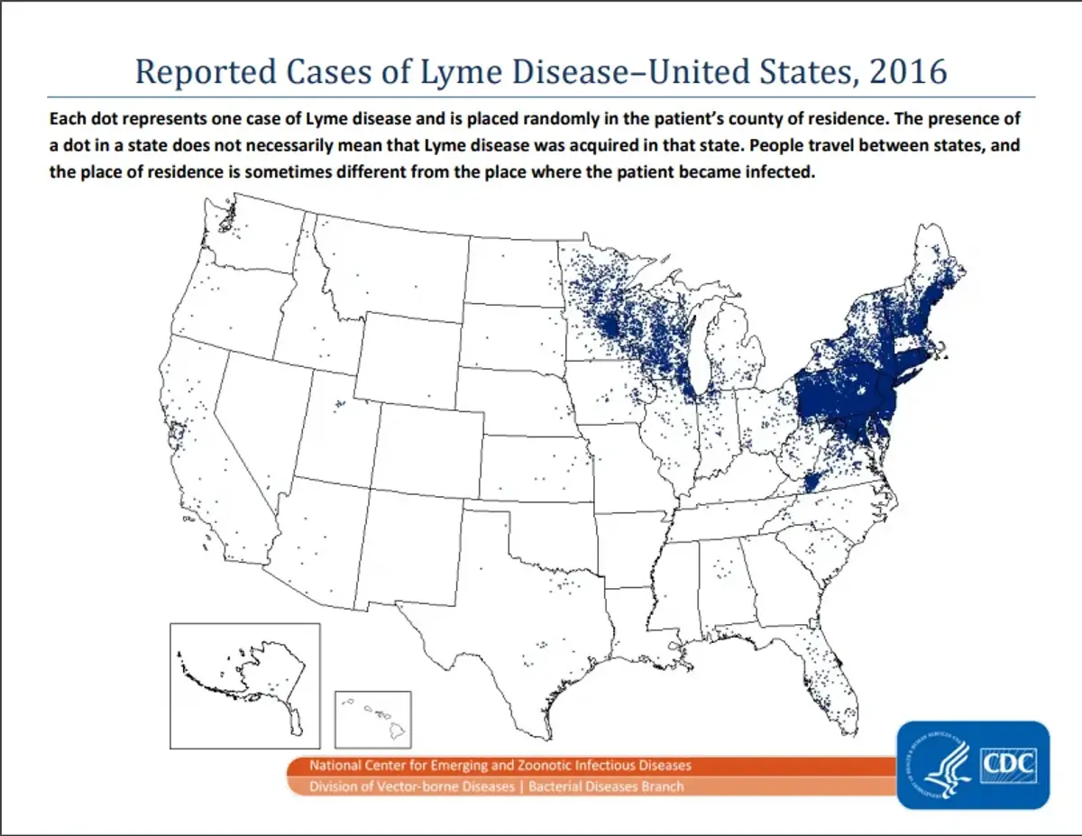
The CDC keeps an updated Lyme disease case map with versions for 1995, 2010, and 2023. Each dot is one reported case, placed in the county where the patient lives. That’s not always where they were bitten. The CDC says the range of reported cases has expanded significantly since 1995.
The cases cluster hard. According to a 2024 CDC report, 62,551 Lyme disease cases were reported in 2022. High-incidence jurisdictions accounted for 95.5% of them. That list includes Virginia, Maryland, and the District of Columbia, along with most of the Northeast plus Minnesota and Wisconsin.
Tick Map for Virginia, Maryland, and DC
National maps shade our whole region the same color. Local health agencies give a sharper picture.
Virginia. The Virginia Department of Health says lone star ticks live all over the state, usually below 1,600 feet. They are common on the coast and in the Piedmont. Blacklegged ticks show up in suburban woods in the Piedmont and the mountains, where deer are common. American dog ticks are found statewide in sunny, open areas. In Fairfax County, the health department says the lone star tick is the most commonly found tick.
Maryland. The same three ticks dominate. Lyme disease is the most commonly reported tick-borne disease in the state, with over 3,000 cases reported in 2024, according to the Maryland Department of Health.
DC. The District sits inside the ranges of all three major eastern ticks, and it’s on the CDC’s high-incidence list for Lyme disease.
For a deeper, state-by-state look, see our guides to ticks in Virginia and ticks in Maryland.
Virginia’s Lyme disease map has changed a lot in a short time. A 2014 study in Emerging Infectious Diseases looked at human cases from 2000 to 2011. The researchers found that cases “progressed from county to county from northeast to southwest” across the state.
They also collected ticks in 2011. Infected ticks were densest at their highest-elevation site, and Virginia’s blacklegged ticks were more closely related to northern populations than to southern ones. Basically, that points to Lyme moving down from the Northeast rather than spreading up from the South.
How to Read a Tick Map
Every tick map comes with fine print. Here’s what to keep in mind.
- Shaded doesn’t mean dangerous. The CDC says a tick being present doesn’t necessarily mean it spreads a specific disease in that area.
- Unshaded doesn’t mean tick-free. Tick populations can be found outside the shaded areas. A county not labeled “established” doesn’t mean ticks are absent, either.
- Range maps are coarse. They work at the state and county level. They can’t tell you about one neighborhood, let alone one yard.
- Case maps show home addresses. Lyme disease dots sit in the patient’s county of residence. Someone can live in one county and get bitten on vacation in another.
- Check the date. Tick ranges shift. The lone star tick and the Asian longhorned tick have both spread a lot in recent years, so an old map can mislead you.
I learned how uneven tick numbers can be on a road trip. I had to pull over and step into a field for a minute. When I walked back out, I had four ticks on my leg. The map didn’t change between the road and the field. The habitat did.
Our technician Daren sees the same thing on jobs. He services a Fort Hunt property with a creek and thick woods behind the house, plus lots of deer and fox traffic. One summer he walked out of that yard with 15 or 16 ticks on him. To this day he checks his pant legs every time he leaves, because he knows they’ll be there. Houses a few streets over, with open lawns and less wildlife, don’t look anything like that.
What the Map Means for Your Yard
If you live in the DMV, the tick map already answered the big question: yes, ticks live here. So the more useful question is where they live on your property.
Ticks can be anywhere there’s grass, but they gather in specific spots:
- Shaded areas under trees and along fence lines
- Thick brush and overgrown shrubs
- Leaf litter, which dog ticks especially like
- Tall grass and the edge where lawn meets woods
- Low tree limbs and groundcover near deer paths
If you do find a tick on you or your pet, our tick removal guide walks through how to take it off. Additionally, our tick season guide covers which months each life stage is most active here.
Professional Tick Control in the DMV
Our tick control service targets the spots where ticks actually live: wooded edges, shrub beds, leaf litter, and shady borders. Our licensed technicians treat on a schedule through the season. That matters, because deer and other wildlife keep carrying new ticks in.
Mosquito and tick plans start at $75 per service. Pricing goes up with yard size and application time, and seasonal plans bring the per-visit cost down. All the products we use are EPA approved, and they’ve passed through our internal research team. Each one is something we’d feel comfortable using around our own homes.
We serve homes across Northern Virginia, DC, and the Maryland suburbs. Many of our customers add tick treatments to mosquito control in Northern Virginia, including Loudoun County mosquito and tick service, where wooded lots are common.
Conclusion
A tick map is a great starting point. It tells you which ticks live in your region and roughly how far they’ve spread. In the DMV, the answer is the blacklegged tick, the lone star tick, and the American dog tick, with the Asian longhorned tick now in the mix. However, the map can’t tell you how many ticks are in your yard. Shade, brush, leaf litter, and wildlife traffic decide that.
If you have questions about ticks around your home, or you’d like an estimate, call us at 703-683-2000 or email info@bettertermite.com. We’ve been doing this for 58 years and have earned 1,800+ reviews from homeowners across the region.